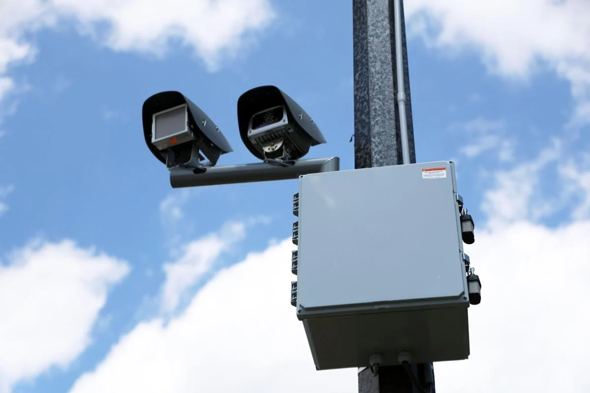
BRAMPTON, ON – The City of Brampton has significantly ramped up its efforts to curb speeding, announcing the installation of 50 new pole-mounted Automated Speed Enforcement (ASE) cameras, bringing the city’s total active photo radar units to 150. This expansion is part of a larger plan to increase the number of cameras to 185 by the end of July.
Brampton first introduced ASE cameras in community safety zones in 2020, initially deploying 50 ground-mounted units that were rotated across different areas. Recognizing issues with vandalism on the older units, the city began phasing out ground-mounted cameras in 2024 in favour of more robust pole-mounted systems, with a target of 200 new installations. The latest 50 cameras are now active and are strategically placed to enhance road safety, particularly near schools, parks, and in residential neighborhoods.
Understanding the Fine Structure:
While the exact speed threshold for issuing tickets remains undisclosed, the City of Brampton outlines its fine structure for speeding in Community Safety Zones as follows:
- 1 to 19 km/h over the limit: $5 per kilometre over, plus additional costs.
- 20 to 29 km/h over the limit: $7.50 per kilometre over, plus additional costs.
- 30 to 49 km/h over the limit: $12 per kilometre over, plus additional costs.
It’s important to note that ASE tickets result in a monetary fine for the registered plate holder and do not incur demerit points.
New Camera Locations Across Brampton Wards:
The newly installed 50 cameras are distributed across various electoral wards. Here’s a breakdown of the approximate new locations:
WARD 1
- Kingswood Drive, near Merton Road
- Madoc Drive, north of Lauderdale Road
- Vodden Street East, west of Leeward Drive
- Ken Whillans Drive, north of Church Street East
WARD 5
- Parity Road, south of Argelia Crescent
- Jordensen Drive, north of Lackington Street
- Antibes Drive, east of Jordensen Drive
- Gretna Drive, north of Cambridge Crescent
- Ingleborough Drive, east of Elbern Markell Drive
- Richmead Road, west of Parity Road
- Dwellers Road, east of Fletcher’s Creek Boulevard
- Parkway Avenue, west of Cambridge Crescent
WARD 2
- Colonel Bertram Road, north of Hambley Court
- Burnt Elm Drive, north of Milkweed Crescent
- Monte Vista Trail, north of Kerwood Place
- Wexford Road, east of Dundalk Crescent
- Colonel Bertram Road, south of Penrose Court
- Kennedy Road, south of Notre Dame Avenue
- Kennedy Road, south of Wexford Road
WARD 6
- Queen Mary Drive, south of Sunnybrook Crescent
- Worthington Avenue, south of Clayborne Avenue
- Heatherdale Road, south of Continental Road
- Tribune Drive, east of Robert Parkinson Drive
- Veterans Drive, north of Yardmaster Drive
- Kanata Road, west of Queen Mary Drive
- Worthington Avenue, south of Spencer Drive
- Creditview Road, south of Buick Boulevard
- Remembrance Road, west of Fryent Street
WARD 3
- Abbey Road, north of Pleaseley Road
- County Court Boulevard, east of Turtlecreek Boulevard
- County Court Boulevard, south of Bloomingdale Drive
- Clarence Street, east of Hurontario Street
- Duncan Bull Drive, west of Melville Crescent
WARD 4
- Sterritt Drive, west of Drinkwater Road
- Cherrytree Drive, north of Patricia Court
WARD 7
- Dearbourne Boulevard, east of Dorset Drive
- North Park Drive, west of Massey Street
- Birchbank Road, west of Belmont Drive
WARD 8
- Finchgate Boulevard, north of Festoon Place
- Tappet Drive, west of Pinestaff Road
- Greenbriar Road, south of Glenfield Crescent
- Cottrelle Boulevard, west of Prince Edward Boulevard
- McVean Drive, north of Tappet Drive
WARD 9
- Masjid Drive, east of Great Lakes Drive
- Wardenwood Drive, south of Trentonian Street
- Ross Drive, south of Countryside Drive
- Peter Robertson Boulevard, east of Dandelion Road
WARD 10
- Via Romano Way, north of Alfredo Avenue
- Meltwater Crescent, east of Long Branch Trail
- Clarkway Drive, north of Singletree Road
Residents can access an interactive map on the City of Brampton’s website to view all active camera locations, as well as designated Community Safety Zones where ASE technology may be deployed in the future.
A.M. Headlines Newsletter